Montara Mountain Hike and Trail Map
Today I want to share my guide to a Montara Mountain hike with you. Spanning McNee Ranch State Park and San Pedro Valley County Park in the Santa Cruz Mountains, this peak is an ideal spot to get outdoors and into nature in the San Francisco Bay Area. Whether you’re looking for a short hike along the coast in San Mateo County or a more challenging route to the top of Montara Mountain, there’s a path for you. There are plenty of trails to keep you coming back, too.

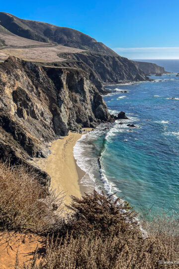
Montara Mountain Hike
The hike I’m telling you about today is in McNee Ranch State Park. It’s located just south of Pacifica on the Pacific Ocean. It covers 690 acres and it’s open from 8am to sunset.
Within the park, Montara Mountain rises 1,898 feet above sea level. The area is home to hiking trails that lead to the North Peak of the mountain and other destinations in and around Montara State Beach. It's a great day trip from San Francisco.

McNee Ranch State Park
McNee Ranch is known for its steep seaside topography, foggy summer weather, and granitic soil. There are rare plant and animal species here, including the San Bruno Elfin Butterfly, Hickman’s Potentilla, and Montara Manzanita.
At sea level, Coastal Scrub plants thrive. These include Bee Plant, Coast Buckwheat, Coyote Brush, and California Blackberry. They survive by growing close to the ground, avoiding the strong winds and sea salt spray from the Pacific Ocean.

Higher up the hill, Maritime Chaparral plants and scrubs grow. These include Sticky Monkeyflower, Coast Silk-Tassel, Ceanothus, San Mateo Tree Lupine, and Golden Chinquapin.
In terms of fauna, you might spot birds like the Turkey Vulture, California Thrasher, American Kestrel, Wrentit, and Red-shouldered hawk. Closer to the ground, small lizards are common sights. Less common are mountain lions and coyotes, foxes, bobcats, deer, raccoons, squirrels, and rabbits.

How to Get to Montara Mountain
If you’re wondering how to get to Montara Mountain, there are several options. You can drive south from San Francisco or north from Half Moon Bay on Highway 1 and park along the ocean.
There’s a parking lot at Gray Whale Cove State Beach with plenty of spots near the trailhead. Alternatively, you can park about a mile south at Montara State Beach. You can also access a Montara Mountain trail from San Pedro Valley County Park, which is located slightly inland.

Montara Mountain Hikes
Once you’ve parked, you have a number of options for Montara Mountain hikes, all of which are dog-friendly. They range in distance and difficulty, so there’s an option for everyone.

Gray Whale Cove Trail
If you want an easy hike, the 1-mile Gray Whale Cove Trail is a good one. It will take you from Gray Whale Cove State Beach to Montara State Beach and Highway 1.
After a short incline in the beginning, the path is relatively flat and offers great views of the beaches and coastline below. The trail hugs the coast, so you can enjoy waterfront vistas the whole time.
Once you reach the North Peak Access Road, you can turn around and retrace your steps for the mile hike back to the Gray Whale Cove State Beach parking lot.

North Peak Access Road and Old San Pedro Mountain Trail
If you want something a bit more challenging, you can start on the Gray Whale Cove Trail and continue on the North Peak Access Road or Old San Pedro Mountain Trail.
The former is a fire road that makes for a wide-open trail. The latter has more twists and turns, but it’s also a good option. Both require a gradual uphill climb, so they’re more rigorous than the Gray Whale Cove Trail (but not too challenging).

The North Peak Access Road is 3.9 miles each way. It will take you to the top of Montara Mountain. You can take in great views of the coast and the entire Bay Area from the peak.
The Old San Pedro Mountain Trail leads to Pacifica. It crosses the North Peak Access Road and joins it for a while, so you can switch onto the road to reach the North Peak if you want to. It’s 3.2 miles each way.

Montara Mountain Trail
The Montara Mountain Trail starts from San Pedro Valley County Park. It’s a relatively challenging path that leads up to the North Peak Access Road. From there you can follow the road to the top of the mountain. It’s 2.1 miles each way.

Other Trails
Interspersed among the official trails are lots of smaller paths you can take to switch from one to the other or take shortcuts. For example, there are steep paths leading up from the Gray Whale Cove Trail to the North Peak Access Road near the beginning of the hike if you don’t want to walk all the way along the coast to get to the road.

Gray Whale Cove Trail and North Peak Access Road
When I hike here I do a Montara Mountain loop. I start at the Gray Whale Cove State Beach parking lot and follow the Gray Whale Cove Trail all the way to the North Peak Access Road. From there I hike up the road until I reach a bend right before it meets up with the Old San Pedro Mountain Trail for the second time.

There's a narrow path through some brush on the left, and I follow it all the way down the hill to Gray Whale Cove Trail. From there I turn right and walk back down to the Gray Whale Cove State Beach parking lot. It's a hike of just over 2 miles, and it's a fun way to get outdoors in Montara.
The whole hike takes around an hour, and I've lucked out with sunny days and lots of cotton ball clouds in the sky. I always bring plenty of sunscreen and water, and I wear hiking boots (although tennis shoes or running shoes would suffice).

Montara Mountain Trail Map
Below you’ll find a map of the Montara Mountain trails. You can see the map on boards next to the trailhead in the Gray Whale Cove State Beach parking lot.

Montara Mountain Hike
I hope you’ve found this guide to Montara Mountain hikes helpful, and that you get a chance to do one or all of them yourself someday. They’re great ways to get outdoors by the Pacific Ocean, take in views of the beaches and Bay Area, and get some exercise while you’re at it.
If you want a treat afterwards, you can head to Gray Whale Cove State Beach or Montara State Beach to soak up the California sun (if it’s out) and take in the Pacific Coast scenery.
You can also check out my video about this hike on YouTube. And if you're looking for additional inspiration, I've published blog posts with my favorite Bay Area hikes and my top picks for dog-friendly hikes in San Mateo County. Happy hiking!
Find this helpful? Buy me a coffee!
Some of the links in this blog post are affiliate links. At no cost to you, I earn a small commission when you click on them and make a purchase. It doesn't affect the way you shop, and it's a great way to support the California Wayfaring blog.
Pin it!